I have a question about msfssdk.js data, specifically the returned gates
object from the airport facilities loader. msfssdk.js is the api generated by
Avionics Framework and used all over the place. I want the exact lat/long of
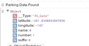
the parking spots, which according to the enums are returned gates entries
with name value <= 9. See image for example of one. The lat long returned for
these JS-Gate objects is not the actual lat.long, but appears to be an X, Y
bias offset in metres from the airport reference point, as described in the
SDK docs.
https://docs.flightsimulator.com/html/Programming_Tools/SimConnect/API_Reference/Facilities/SimConnect_AddToFacilityDefinition.htm#taxi_parkingThere
doesn’t appear to be any info on these object on the Avionics Framework site
so using the nearest equivalent docs from SDK. (Also, search on the AF doc
site would be very handy!) So I tried calculating the lat longs using
Haversine Offset algo (closest I can find that solves this problem) but the
accuracy isn’t there, they are off by many metres. Either the algo is wrong or
my assumptions about the inputs are incorrect, or maybe both! Some questions:
- Am I correct in assuming the parking spots (gates name 0 to 9) lat/long values are metre offsets from the airport reference lat/long? (ie: they are actually the Bias offsets as described in the main SDK docs, bc using them as lat long sends you to crazy places)
- Is the airport reference value the lat/long of the airport from the main map? (airports can have multiple runways, so using main runway lat long doesn’t seem logical, but not assuming anything). If not, what is the base referance point needed to use these offsets from?
- Given the above values and units can be clarified, what is the formula needed to accurately calculate (to sub metre accuracy) the actual lat/long of these parking spots?
Thanks!