This is going deep down the Rabbit Hole, but it would seem that some major
functions of the GPS are based on the incorrect assumption, that thr GPS
relied on data FROM the Nav Receiver, to determine it’s display of it’s
Database information. Taking on of the simpler Garmin GPS system as an example
ie GNS530 Ref: Garmin Trainer - When the GPS is displaying information about
VORs, ILS’s, etc, it’s should be displaying that data based on GPS
information, and NOT from any data that would be got from any Nav receivers.
It should not matter if the Nav radio can pick up one of these Nav Aids or
not, the GPS should only display information from it’s database.(+ aircraft
GPS position) Example: DIS (Distance) to VOR This should be the Horizontal
distance between the Plane’s Position, and the Position of the VOR. GPS gets
Plane position, and then looks up in it’s Database the Position of the VOR,
and displays the Horizontal distance ( not the slant Range : DME) It also does
not care if that VOR is being received by the Nav Receiver, it is in range or
out of range, or even if the VOR is Down, or the Nav radio is OFF. (or of
course, tuned to a different VOR frequency !) If the GPS is told to display
the closest VORs, it should search its Database, and list the nearest, with
number of VORs displayed limited either by number or physical distance. If the
VOR is Low Altitude, with a short range, and the plane is outside that range,
it should still display that VOR, if it meets the Number / physical distance
rule. Currently, if the Nav Receiver cannot receive that VOR, it is ignored in
the List. If it is an ILS, and the plane is outside the ILS cones, then it
does not display that ILS - which is also incorrect. Another Example. A DME
(no radial information info) The Gps should display its Distance AND GPS
bearing. It does not care that the DME does not transmit any Bearing
information… once again, its NOT considering a Nav Receiver input, its purely
displaying the GPS position of the DME Navaid. Distance and Bearing from the
Plane. In fact, the more one looks at the GNS530, comparing it to the true
Garmin (Ref: Garmin Trainer - The Garmin Pilot’s manual can be ambigeous on
some of this ) , the more the operation of the ASOBO MSFS GNS530 is not
following even the basic functionality of the real GPS. So the questions are:
(1) Am I correct, or have I entered the Twilight Zone.? (2) If it is in fact
the modeling of the Garmin is incorrect, does it matter. ? (3) Should it be
corrected, or left to some 3rd Party Mod to make corrections. ?
I’m not sure if I understand what you’re saying, because it seems to me this
is working correctly, like you’re requesting? As long as the GNS430 or the
G1000 in the sim is in GPS mode (purple) it is absolutely using GPS database
data and not nav radios. If you switch it to VLOC (green) it uses data from
the nav radios. Direct to a VORDME in GPS mode and it will show ground
distance and gps bearing to the waypoint regardless of nav radio frequency or
reception. Tune to the frequency and go to VLOC (green) mode and the DME
indicator will show the slant distance when in range. The VORDME shows up in
the nearest list even if out of range or covered by terrain. Seems correct to
me based on the Garmin user manual and what you want, if I understand your
post correctly.
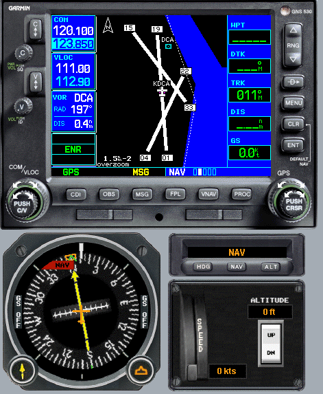
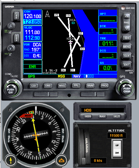
Plane is on the
ground, 0.5 nm from the VOR at the Airport. GPS Mode (not that it make any
difference here) Tuned to the VOR, so GPS reports the VOR at 0.4 nm DISTANCE
================== Then Put plane up to altitude 11,500ft approx 2 miles) GPS
still reports 0.4 Miles – ie DIS is the the Horizontal DISTANCE.
CONCLUSION The ASOBO
GNS530 reports 2 miles, so the ASOBO GNS is reporting 2.0 nm (which is really
DME - Slant range) while the Ref Garmin Trainer is still reporting the correct
DIS = 0.4nm the Horizontal Distance. The DIS display is the GPS calculated
DISTANCE. It is not the DME distance that would come from the nav Receiver.
Nor is it a Calculated Slant range (DME) , as “could” be calculated by the
GPS, as it knows both the Plane’s and the VOR’s Position & Altitude.
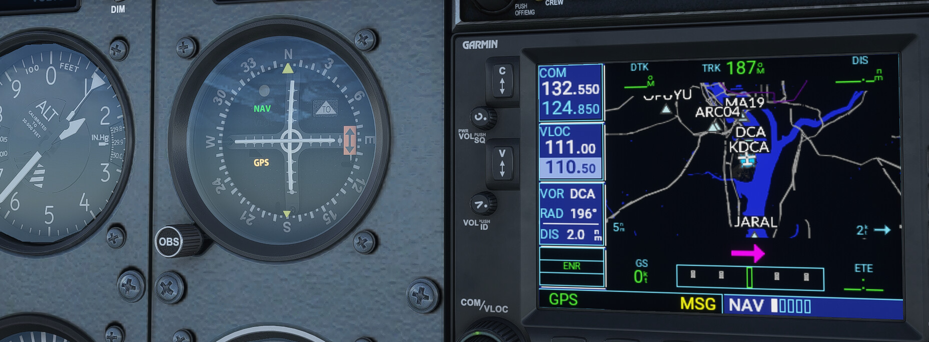
Thanks for the images, they helped me understand the issue. Seems you’re
correct that the VLOC Ident window on the 530 is inaccurately represented. I
also realised I might not have the 530 in any planes in the standard edition
and the 430 doesn’t have the VLOC ident window, so I’m not directly affected.
There seems to be an actively developed mod here: GitHub -
pimarc/pms50-gns530: Flight simulator 2020 GNS530
Mod that you could check out.
The screen shots were with the improvements of the GNS530 Mod …
Unfortunately, for the MOD to correct a lot of these basic design issues, it
would need quite an extensive re-write of a lot of the existing Asobo code (by
the Mod), or better, by Asobo in the base sim.
To assist anyone brave enough to attempt this mod in the future: How should
the GPS determine what to show in the VLOC ident window when you manually tune
a NAV1 frequency? A: Wait for signal from VOR, get ID, match ID with internal
database and use GPS data. B: Use frequency to search internal database, match
with closest station with that frequency even if there is no signal and use
GPS data. C: Something else.
Ref: GNS530 Garmin Trainer. The information displayed in the Windows under the
Frequency Windows, is 100% ONLY from the GPS’s Database. The answer is B.
Those displays should be the same, without relying on any information from a
Nav Receiver Unfortunately, it looks like the content of those windows, are
using data as if it came FROM the Nav receiver, using MSFS simvars that are
designed to provide information about how the Nav Radio receiver is operating,
and what it is able to pick up from ground based Nav stations.
The correct answer is B (if this is the desired behavior). To fix this issue,
one can use the output of the nav ident simvar to look up the radio lat/lon in
the facility loader system, then calc the distance from the plane to that
lat/lon. This is presently doable with the current APIs. -Matt | Working Title
I tried this, but none of the relevant NAV simvars gave me any useable data
without a valid radio signal. If they did, we could just use NAV VOR LATLONALT
to get the location. Option A would be a quicker fix because of this. However,
the BaseGPS.js file looks like it has the needed functions to browse the
nearest VOR list and calculate distances. I don’t have the energy to attack a
problem like this, though. edit: If option A was correct and a signal was
required we could probably just do some math to get the x-component of the
slant distance as a quicker fix.